Wednesday, 15 August 2018

Fownhope, Brockhampton and Capler Camp - Herfordhsire/Wye Valley

This is a walk I'd been meaning to do for a long time. Sat there staring at me from my 2005 edition of Wye Valley and Forest of Dean Walks Pathfinder Guide. This was walk 20 in 2005 and is walk 21 in the 2011 edition. Route information here

The walk starts at the beautiful village of Fownhope in Herefordshire. Parking is free at Fownhope Recreational Ground. There is also two pubs, where you can suitable reward yourself afterwards - The Green Man and The New Inn.

The walk itself has a long version (8.5 miles) and a short version (6 miles). With the weather so lovely I decided to 'go long'. The walk consists of mainly single track lanes in the first half of the walk and returns to the Fownhope via a section of the Wye Valley Walk.


Looking across to Fownhope from the Recreational Ground

From the Recreation Ground, the route is picked up on Capler Lane near the church. Turning right (South) away from Fownhope, the route follows the undulating Capler lane for over a mile, affording some lovely views across the River Wye and the surrounding countryside, before you actually take the track down to the riverside itself (For the short walk, you continue to follow the road uphill and turn left onto the Wye Valley Walk and follow it back to Fownhope). This stretch of the River Wye is so peaceful, my quiet reflection as I walked only broken by the sound of a group of passing canoeists and a swan hissing at me!

After about another mile of riverside tranquillity came the climb. Not particular high by any means, but relatively steep and thankfully shaded by the surrounding woods.


The top of the climb arrives onto a lane leading into the sweet hamlet of Brierly Hill, where the Wye Valley Walk is picked up. The views from Brierly Hill are vast if not obstructed by crop, and you can see as far as May Hill, distinguishable by its cluster of trees on the summit.

Heading first south and then east along the Wye Valley Walk, for little under a mile brings you to the village of Brockhampton. Here the route suggests a field path alongside the village, but the presence of the bovine demons put paid to that, so I diverted further along the road around the east side of the village. Most of Brockhampton is now a retirement complex, but has retained its charm through the preservation of the old buildings. Walking past the manor house, I saw a game of cricket being played on what could have been the lawn! There was a sizable crowd.

At the northern end of the village is Brockhampton Church. I like to visit the churches on walks, especially way out in the country, as the design and architecture can be very unique. Brockhampton Church is no exception. A thatched roof and wooden belfry are two of the charming features of this church.


Brockhampton Church


Signpost at Brockhampton crossroads

Heading north out of Brockhampton for a few hundred metres, I was at Capler Lodge (This is where the earlier diversion to the shorter distance route arrives). There should be a great viewpoint across the west of the Wye Valley, however, its heavily overgrown with trees, so a few brief gaps are all that remain. The view point does have a unique carved bench, each carving detailing features of wildlife, industry and culture of the surrounding area.


The carved bench at Capler Lodge


The view from Capler Lodge

Just past Capler Lodge is the Wye Valley Walk, again. The next leg of the walk takes in this delightful and well marked footpath for approximately 3 miles, back to the outskirts of Fownhope. The walk passes through the remains of the Iron Age Fort - Capler Camp - where there are again magnificent panoramic views to take in across to May Hill and the Marcle Ridge. A mile or so further along is Lea and Pagets Wood Nature Reserve. It's quiet, peaceful and full of wildlife. Colours, smells, birds and the odd surprised Weasel/Stoat. it could be either, all I could see was the body shape and colour so its a best guess.


Shortly after leaving Lea and Pagets Wood, is the small community of Common Hill. Common Hill has a unique tourist information office, which has been established in a disused red telephone box. This is located to a recently restored water pump.


Common Hill Tourist Office
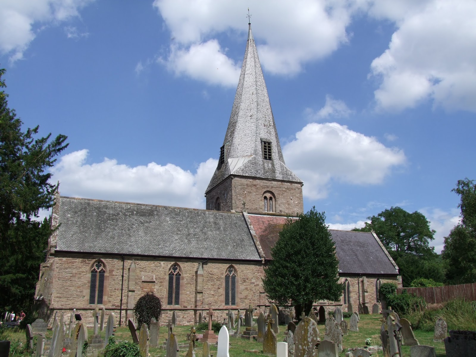

Fownhope Church

I really enjoyed this walk, with such a range of things to see and views to take in. Its challenging in places, but fairly straightforward to navigate, meaning time can be taken to enjoy where you are, rather than work out where to go next. I'll be heading back here at some point methinks.


Sunday, 16 July 2017

Skirrid Fawr

First day of a week's holiday and we've decided to take Bonnie up Skirrid Fawr in the Black Mountains. The main aim being to see how well Bonnie coped with a mountain, albeit on a much smaller scale.

We arrived at the National Trust Car Park at the Southern end of Skirrid Fawr with slightly overcast skies and a fresh breeze, perfect walking weather. Being a week day it was also very quiet, save for the occasional dog walker.


The walk is very easy to navigate, following a well constructed footpath and signs through the woods on the lower slopes, climbing steeply up onto the ridge of Skirrid Fawr. The ridge is then followed climbing gradually up onto the highest point at the Northern end, where the remains of an old chapel can be found. 

Being a single peak, Skirrid Fawr affords excellent 360 degree panoramic views. On our walk we could see across to Pen Y Fan in the West and the Severn Estuary in the East.


Bonnie coped remarkably well with the walk, although she scoffed her body weight in sheep poop along the way. She's such a dirty dog.
We stopped at the top for the obligatory photos and rest, and then made our way back down to the car park.


Monday, 26 June 2017

Forest of Dean Sculpture Trail

The weather has finally cooled enough to get Bonnie out and about exploring. Over the weekend we went to the Forest Of Dean Sculpture Trail. Not just some exercise for Bonnie, but some culture too. The route is too complicated to explain, but route maps can be bought for £1 at the Forestry Commission cafe at Beechenhurst Lodge. The trail itself is about 5 miles long, allowing for finding the sculptures and walking around them. Bonnie had a great time exploring, even bumping into wildlife in the form of deer and an unknown beast  we suspect was a bore hidden in the bushes.

The paths around the trail are well maintained and signposted.


Wednesday, 21 June 2017

Penallt and Millstone Country - 18th June

Having been frustrated recently with my lack of walking, be it through lack of time or lack of motivation, I finally got my rotund self moving on the hottest day of the year. It was too hot for Bonnie so she sat this one out at home. I picked this walk out of my latest version of the Wye Valley and Forest of Dean Pathfinder guide. If anyone has got it, this was route 4. 4 1/2 miles in distance.

I decided to pack light. Phone, book and camelbak.

The walk starts at the pay and display car park in Redbrook. Parking is £1.60 all day at time of writing. Setting off from the car park in the direction of the sports field (south) and heading for The Boat pub. (Yes, that's right, a walk that starts with heading for a pub!) Searching out and finding the footbridge across the River Wye to the pub, I was treated to the most beautiful views up and down the Wye Valley. The bridge sits about 15 metres above river level and once carried the Wye Valley rail line between Chepstow and Monmouth before closing in 1964.


After crossing the bridge, turn right and pass in front of The Boat pub. On nice weather days the pub can heave, with customers sat all along the river bank enjoying refreshments. Continue walking along the road until you reach a gate slightly off to the right and signposted to Monmouth. Go through and walk through meadow after meadow alongside the River Wye. In summer the vegetation can be very overgrown so trousers are recommended (I got stung and bitten a few times). Eventually, you'll enter Washing's Wood. Keep a look out for a signposted path on the left, heading uphill. Take the path uphill, turning right at the next 2 junctions. This will bring you onto a narrow tarmac lane, still continuing uphill, but more steeply. Near the top as the gradient starts to level, you'll reach The Old Church at Penallt on the right. Small, peaceful and scenic.


With your back to the church, set off straight ahead and slightly uphill. Shortly after, you pass Church Hill Common, opposite which are some stunning views across the Wye Valley to Gloucestershire. As the road bends round to the right, on the left you will find the Cross Dermond Coffin Stone. Coffins were set upon this to allow pall bearers a rest on the way to church for burial.


From the Coffin Stone, continue along the tarmac lane until you pass a turning on the left. Continue straight on and shortly after take a stile on the left into a small wood. Follow the woodland path to another stile set in a stone wall. Cross this and head straight across the small enclosure towards a gate. Turn right in front of the gate (there's a yellow footpath sign high up in one of the trees) and head along the enclosure perimeter to another stile that crosses onto a tarmac lane.


Turning left along the lane pass a newly constructed house on the left before taking a bridleway on the right signed to Pen Y Garn and Pen-twyn.


Continue along this, looking out for a stile on the left that leads into a field. Continue across the field keeping the hedged boundary on your left and proceed through a gap into the next field. Continue across this as before, keeping the boundary on your left to cross a stile into a hedged path. Follow this onto open heathland, heading towards a property on the right. The lane heads behind this property on the right to cross a stile onto a tarmac lane. 

Turn immediately left, then right at the junction, then left down a lane towards The Inn at Penallt . A lovely village pub that serves excellent food.


Looking towards the pub car park entrance, take a grass track off to the right passing to the right of Pen-twyn cottage.


Follow this to meet another tarmac lane and turn left, heading down hill for 3/4 of a mile. Keep a look out on the right for a new allotment slightly uphill from an old barn building with a totem pole (yes a totem pole). Mid distance along the lane between the allotment and house is a gravel track signposted to the River Wye. Take this and follow it down beside a wood store and through a gate leading to a stepped, down hill path. At the bottom you have 2 options. Either proceed straight ahead through a gate to the river bank, and turn left following the path back to The Boat or you can turn immediately left  and follow the old railway track bed back to The Boat. Both meet at the same place, the only difference being view and terrain. On this occasion I took the riverside view.


Once back at The Boat, you just cross the footbridge back to the car park. An enjoyable and mildy challenging walk, but with some outstanding scenic views and 2 cracking country pubs.


Monday, 5 June 2017

Bonnie needs some miles

With the challenge walks now out of the way, I'll be aiming to get young Bonnie out and about, exploring the Welsh countryside. The little monkey, adorable as she is, has a disgusting appetitite for animal muck. Rabbit, cow, sheep, you name it, she's probably munched on it.

While I have some ideas on where to take her,  I am open to suggestions from other dog owners as to where the good walks with dogs are, so please do get in touch.

Progress update - It's been too long!!

So, it has been a good few months since my last update, which is really very slack of me.

On Saturday 13th May I undertook, and completed, the Big Black Mountains Challenge (BBMC) Route B. This route was 32km in distance and consisted of 2 steep climbs and 2 long ridge walks, which was simple enough for navigating.

Arriving on the day, the sky was overcast, but it wasn't cold. Soon after starting the course during the first climb, the rain started. Light and drizzly to start with, gradually getting heavier the higher I got. At the top of the first climb the wind strength was immense. To make things worse, it was blowing across the first ridge. That 10 mile stretch was awful, driving rain being blown at force into me, was similar to hail.


Thankfully the rain broke at the end of the first ridge for about 30 minutes, before promptly letting rip again on the descent from Lord Hereford's Knob (yes, there really is a hill by that name!). This time it was a short shower and had pretty much dissipated by the time I started the climb up Hay Bluff.


Reaching the top of Hay Bluff and then heading South, the weather improved all the time. The wind died, the skies cleared and Llanthony Priory was bathed in sunshine by the time I returned to the start 7 hours after starting. My feet had blistered (I really do need some new boots), but I felt good. I scoffed no end of cake in the tent at the end.


Sunday, 16 April 2017

Black Dragon Challenge Walk - Saturday 8th April

The second of my challenge walks for the year was the Balck Dragon Challenge Walk. 25 miles and approximately 7,000ft of climbing (route details here). The weather on the day was clear and sunny with not even a hint of a breeze. I also had a companion for this walk. Faye, who'd I met on the South Wales 3 Peaks Trial, had also entered.

Having registered at Crickhowell High School, we set off at the 8am start time. A little bit unnecessary I felt, seeing as those who had registered when registration opened at 7am were then hanging around instead of making progress in the cooler conditions.

The first 5 miles was a gradual climb up to the summit of Crug Mawr, half on road and half footpath. the going was relatively straightforward and the cool conditions were well received. We made the summit of Crug Mawr in 90 minutes. Not bad going I thought!


On the climb upto Crug Mawr


Looking across to Table Mountain and Pen Cerrig-calch. To be tackled in the last 5 miles

Having made the checkpoint at Crug Mawr, the next checkpoint was 5 miles north along the ridge to Waun Fach. Along the way we'd take in the peaks of Pen Twyn Mawr and Pen Y Gadair Fawr. The going was a bit tougher underfoot. The ground was cut up and boggy in places, but we still felt like we were making good time. That said we were seeing noticeably less people than in the first 5 miles.


After waht seemed like an eternity, we finally reached the checkpoint at Waun Fach. We stopped to have a quick lunch before the descent to Pengenffordd. Anyone who has been to the summit of Waun Fach will tell you its a barren, awful place. It has been restored and managed in recent years, removing the need to bog hop from grass tuft to grass tuft, although the crater from where the Trig Point used to be still remains.

We took to the new footpath off Waun Fach, heading via Pen Trumau instead of Y Grib. This would save us about half a mile in distance and be and easier descent.

About halfway down to Pengenffordd it became noticeably warmer. We were out of the breeze and could now feel the sun that had been beating down on us the entire time. It was unbearable and couldn't have come at a worse time.


The highest points in the Black Mountains, Waun Fach and Pen Y Gadair Fawr


Looking South from Pen Trumau

We arrived at Pengenffordd hot, red and sweaty. I was out of water so was glad to be able to refill. It was then we were informed we had 2 hours to make the next 3 checkpoints. That was a kick in the proverbial! The first 2 were atop the peaks of Mynydd Troed and Mynydd Llangorse!!

Having filled up with water, we made hastily for Mynydd Troed. Then it happened. I hit the wall at the worst possible time. Halfway into the climb up Mynydd Troed's northern ridge. It wasn't a tough or long climb, but having already banked 14 miles on my legs under the heat of the sun I was out of energy. My heart rate soared to 180bpm as I struggled my way, step-by-step, up the ridge. All the time Faye was encouraging me, moving ahead to keep me motivated.

After what seemed like hours (but was less than 30 minutes) we reached the Trig Point marked with red welsh dragons. That left 90 minutes to make it to the summit of Mynydd Llangorse and then the road checkpoint at Pentre. 

I was having a realisation. We weren't going to make it (well I wasn't). I was spent, my legs were heavy and felt empty, and I could feel the sun burn on my neck (how I forgot to put lotion on there of all places I'll never know) and the heat of the day had got me. I talked options with Faye. Even if we did by some chance make it in time, we still would have to climb Pen Allt-Mawr inside the last 5 miles and I didn't have the energy in me. The guy on the checkpoint mentioned that we could make a decision at the bottom of the saddle between Mynydd Troed and Mynydd Llangorse as the road the checkpoint was on ran right through our path.

We set off down hill and it was steep. I was struggling to control my legs and locked my knees out on a few occasions. This was one challenge walk that lived up to its name as a 'challenge'. Upon making the road I was honest with Faye. I was not going to make it up and down again in the time needed, and I wasn't going to attempt it and risk putting myself in difficulty. Faye agreed. We'd given it a good shot, but the Black Dragon had beaten us, me for a second time. We turned left along the road and set off on the final 2 miles of our day towards the checkpoint and a lift home. 


View from Mynydd Troed over Llangors Lake and towards Pen Y Fan

Upon reaching the checkpoint, I was surprised by how many people had dropped out. The heat had obviously caught a lot of people out, and thankfully people made honest decisions to remove themselves from trouble, me included.

After 18 miles and 4,000ft of ascent, Faye and I were pleased to take a seat in the shade and wait for a lift. It had been a good effort, but a challenge much tougher than any I have undertaken. I may not have completed the challenge, I may never, but I did exhaust myself trying, and still managed 18 miles towards my 1000 mile target.